Kolkata Metro — Routes, Fares, Maps, Station Info and Train Timings
Kolkata Metro connects 55+ stations across Kolkata and the Kolkata metropolitan area. Find route maps, check fares, explore all metro lines, and get first and last train timings for every station — all in one place.
Where are you travelling today?
Kolkata Metro Network Overview
Find essential details about the Kolkata Metro Network, including operational information, train timings, network scale, and key contact details. This overview helps you quickly understand the system before planning your journey.
Launched Year
1984
Total Lines
5+
Total Stations
55+
Train Length
6 / 8 Coaches
First Train
6:40 AM
Last Train
10:30 PM
Operator
Metro Railway, Kolkata (Indian Railways)
Owner
Government of India (Ministry of Railways)
Helpline
9007041844
Kolkata Metro Network Map 2026
View the latest Kolkata Metro Network Map (2026) with all operational lines and stations. The map shows line colors, station sequence, and interchange points to help you understand the network layout and plan your journey more efficiently.
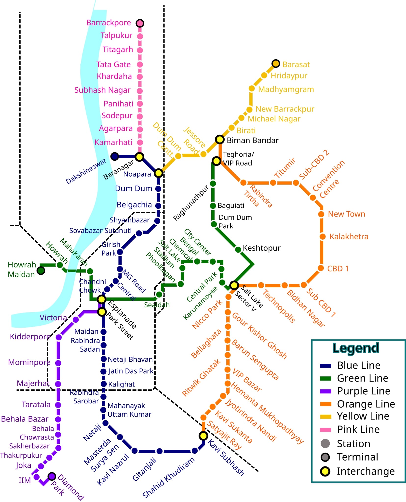
Click to view full size
Kolkata Metro Lines & Stations
Kolkata Metro operates 5 lines covering major areas of the city. The Blue Line, Green Line, Purple Line, Yellow Line, and Orange Line connect different parts of the city, making travel convenient and efficient.
Find below the details of all metro lines and stations:
Blue Line
Dakshineswar – Kavi Subhash (New Garia)
Key Areas: Dakshineswar, Noapara, Dum Dum, Belgachia, Shyambazar, Girish Park, Mahatma Gandhi Road, Central, Park Street, Maidan, Rabindra Sadan, Jatin Das Park, Kalighat, Rabindra Sarobar, Mahanayak Uttam Kumar, Kavi Subhash
Green Line
Salt Lake Sector V – Howrah Maidan
Key Areas: Salt Lake Sector V, Karunamoyee, Central Park, City Centre, Bengal Chemical, Salt Lake Stadium, Phoolbagan, Sealdah, Esplanade, Mahakaran, Howrah, Howrah Maidan
Purple Line
Joka – Majerhat
Key Areas: Joka, Taratala, Sakherbazar, Behala Chowrasta, Behala Bazar, Thakurpukur, Majerhat
Yellow Line
Noapara – Netaji Subhas Chandra Bose International Airport
Key Areas: Noapara, Dum Dum Cantonment, Jessore Road, Netaji Subhas Chandra Bose International Airport
Orange Line
Beleghata – Kavi Subhash (New Garia)
Key Areas: Beleghata, Bansdroni, Ritwik Ghatak, VIP Bazar, Hemanta Mukhopadhyay, Kavi Sukanta, Jai Hind, Sealdah South, Kavi Subhash
Explore More Cities
Looking for other metros in India?