This metro route map shows how to travel from Dahisar (East) Metro Station to Dharavi Metro Station using the Mumbai Metro. It includes the complete route map, platform details, total distance, travel time, interchange stations, fare information, and entry and exit gates. You can also check first and last metro timings to plan a smooth and convenient journey.
Fastest Route (77 Minutes) Via Red Line 7•Foot Overbridge•Blue Line 1•Aqua Line 3
25 Stations
3 Interchanges
₹50
25 Stations
3 Interchanges
₹50
Alternative Route (92 Minutes) Via Yellow Line 2A•Skywalk•Blue Line 1•Aqua Line 3
31 Stations
3 Interchanges
₹60
31 Stations
3 Interchanges
₹60
Dahisar (East) to Dharavi Metro Route Details
Dahisar (East) to Dharavi Metro Route Summary
Dahisar (East) Metro Station Entry & Exit Gates
Entry and exit gate information is currently not available for this station. We are working to update this information.
Dharavi Metro Station Entry & Exit Gates
Gate B1: Sion Central Suburban Railway Station, Dharavi Bus Depot
Gate A1: Dharavi 60 Feet Road, Sion Hospital & Medical College
Gate A2: Dharavi 60 Feet Road, Khemkar Chowk
Gate B2: Leather Goods Market, Dharavi T Junction, Ganpatrao Tapase Chowk
Mumbai Metro Network Overview
Find essential details about the Mumbai Metro Network, including operational information, train timings, network scale, and key contact details. This overview helps you quickly understand the system before planning your journey.
Launched Year
2014
Total Lines
4+
Total Stations
68+
Train Length
4 / 6 / 8 Coaches
First Train
5:30 AM
Last Train
11:30 PM
Operator
Mumbai Metro Rail Corporation Limited
Owner
Mumbai Metro Rail Corporation Limited (Joint Venture of Government of India and Government of Maharashtra)
Helpline
18008890808
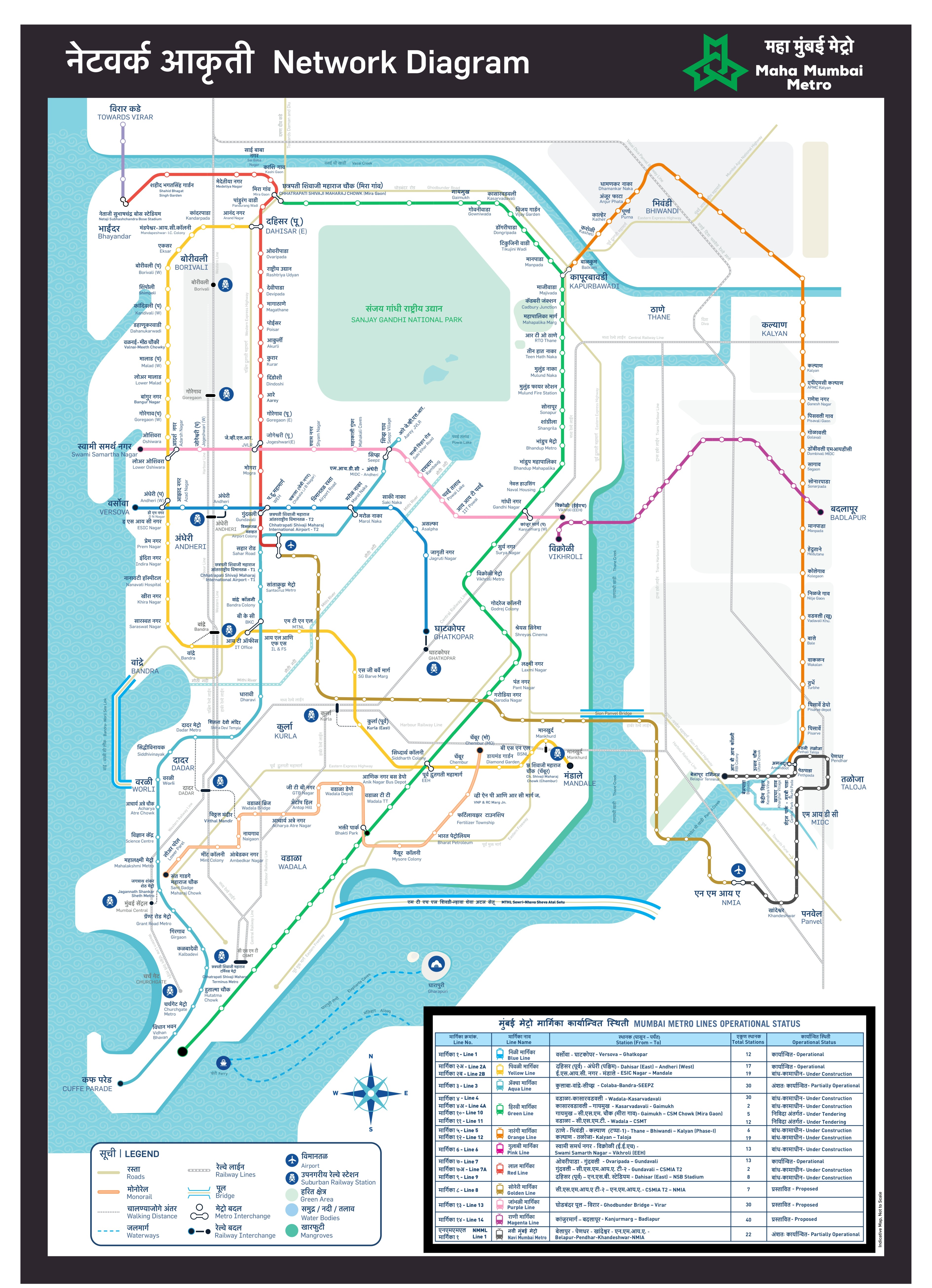
Mumbai Metro Network Map 2026
View the latest Mumbai Metro Network Map (2026) with all operational lines and stations. The map shows line colors, station sequence, and interchange points to help you understand the network layout and plan your journey more efficiently.
Click to view full size
Frequently Asked Questions
The travel time from Dahisar (East) to Dharavi depends on the route you choose. We have found 2 routes between these stations:
• Alternative Route: ~92 Minutes (3 Interchanges at Andheri (West), D N Nagar, Marol Naka)
• Fastest Route: ~77 Minutes (3 Interchanges at Gundavali, Western Express Highway, Marol Naka)
The distance between Dahisar (East) and Dharavi varies depending on which route you take:
• Alternative Route: ~31.9 Kilometers
• Fastest Route: ~27.1 Kilometers
Interchange requirements vary depending on the route you choose:
• Alternative Route: 3 Interchanges at Andheri (West), D N Nagar, Marol Naka
• Fastest Route: 3 Interchanges at Gundavali, Western Express Highway, Marol Naka
MetroYatra automatically highlights the interchange points and platform directions to make your journey easier.
The metro fare varies depending on which route you take:
• Alternative Route: ₹60
• Fastest Route: ₹50
Exact fare may vary based on the type of token or card used and the time of day (peak or off-peak).
The metro lines used vary depending on the route:
• Alternative Route: Yellow Line 2A, Skywalk, Blue Line 1, Aqua Line 3
• Fastest Route: Red Line 7, Foot Overbridge, Blue Line 1, Aqua Line 3
MetroYatra shows a detailed map and train direction at each interchange.
We found 2 routes between Dahisar (East) and Dharavi. The best route is the fastest one, taking around 77 minutes via Red Line 7•Foot Overbridge•Blue Line 1•Aqua Line 3.
Route Details:
• Duration: ~77 Minutes
• Distance: ~27.1 Kilometers
• Interchange: 3 Interchanges at Gundavali, Western Express Highway, Marol Naka
• Fare: ₹50
• Metro Lines: Red Line 7•Foot Overbridge•Blue Line 1•Aqua Line 3
Note: Routes are sorted by shortest path first, then by fewest interchanges. Travel times are estimates and may vary based on actual metro schedules.
Found incorrect information? Help us improve!