Mahatma Gandhi Road to Jai Hind (Netaji Subhas Chandra Bose International) Airport Metro Route Map
Kolkata Metro • 1 Metro Route Found
This metro route map shows how to travel from Mahatma Gandhi Road Metro Station to Jai Hind (Netaji Subhas Chandra Bose International) Airport Metro Station using the Kolkata Metro. It includes the complete route map, platform details, total distance, travel time, interchange stations, fare information, and entry and exit gates. You can also check first and last metro timings to plan a smooth and convenient journey.
Fastest Route (29 Minutes) Via Blue Line•Yellow Line
10 Stations
1 Interchange
₹0
10 Stations
1 Interchange
₹0
Mahatma Gandhi Road
Girish Park
Shobhabazar Sutanuti
Shyambazaar
Belgachia
Dum Dum
Noapara
Noapara
Dum Dum Cantonment
Jessore Road
Jai Hind (Netaji Subhas Chandra Bose International) Airport
Mahatma Gandhi Road to Jai Hind (Netaji Subhas Chandra Bose International) Airport Metro Route Details
Mahatma Gandhi Road to Jai Hind (Netaji Subhas Chandra Bose International) Airport Metro Route Summary
Mahatma Gandhi Road Metro Station Entry & Exit Gates
Entry and exit gate information is currently not available for this station. We are working to update this information.
Jai Hind (Netaji Subhas Chandra Bose International) Airport Metro Station Entry & Exit Gates
Entry and exit gate information is currently not available for this station. We are working to update this information.
Kolkata Metro Network Overview
Find essential details about the Kolkata Metro Network, including operational information, train timings, network scale, and key contact details. This overview helps you quickly understand the system before planning your journey.
Launched Year
1984
Total Lines
5+
Total Stations
55+
Train Length
6 / 8 Coaches
First Train
6:40 AM
Last Train
10:30 PM
Operator
Metro Railway, Kolkata (Indian Railways)
Owner
Government of India (Ministry of Railways)
Helpline
9007041844
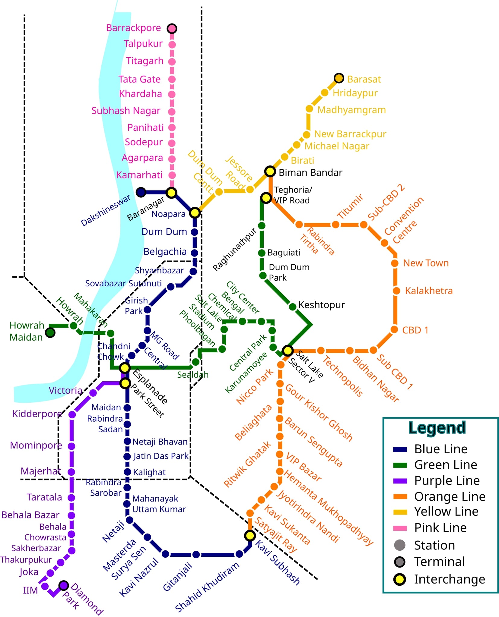
Kolkata Metro Network Map 2026
View the latest Kolkata Metro Network Map (2026) with all operational lines and stations. The map shows line colors, station sequence, and interchange points to help you understand the network layout and plan your journey more efficiently.
Click to view full size
Frequently Asked Questions
The travel time from Mahatma Gandhi Road to Jai Hind (Netaji Subhas Chandra Bose International) Airport is approximately 29 minutes.
This route requires 1 interchange at Noapara.
The distance between Mahatma Gandhi Road and Jai Hind (Netaji Subhas Chandra Bose International) Airport is approximately 13.0 kilometers.
Yes, this route requires 1 interchange at Noapara.
MetroYatra automatically highlights the interchange points and platform directions to make your journey easier.
The metro fare from Mahatma Gandhi Road to Jai Hind (Netaji Subhas Chandra Bose International) Airport is ₹0.
Exact fare may vary based on the type of token or card used and the time of day (peak or off-peak).
The route from Mahatma Gandhi Road to Jai Hind (Netaji Subhas Chandra Bose International) Airport uses the following metro lines: Blue Line, Yellow Line.
MetroYatra shows a detailed map and train direction at each interchange.
The route from Mahatma Gandhi Road to Jai Hind (Netaji Subhas Chandra Bose International) Airport takes around 29 minutes via Blue Line•Yellow Line.
Route Details:
• Duration: ~29 Minutes
• Distance: ~13.0 Kilometers
• Interchange: 1 Interchange at Noapara
• Fare: ₹0
• Metro Lines: Blue Line•Yellow Line
Note: Routes are sorted by shortest path first, then by fewest interchanges. Travel times are estimates and may vary based on actual metro schedules.
Found incorrect information? Help us improve!