Nangloi Railway Station to MG Road Metro Route Map
Delhi Metro • 1 Metro Route Found
This metro route map shows how to travel from Nangloi Railway Station Metro Station to MG Road Metro Station using the Delhi Metro. It includes the complete route map, platform details, total distance, travel time, interchange stations, fare information, and entry and exit gates. You can also check first and last metro timings to plan a smooth and convenient journey.
Fastest Route (95 Minutes) Via Green Line•Pink Line•Yellow Line
33 Stations
2 Interchanges
₹64
33 Stations
2 Interchanges
₹64
Nangloi Railway Station
Nangloi
Maharaja Surajmal Stadium
Udyog Nagar
Peeragarhi
Paschim Vihar West
Paschim Vihar East
Madipur
Shivaji Park
Punjabi Bagh West
Punjabi Bagh West
ESI Basaidarapur
Rajouri Garden
Mayapuri
Naraina Vihar
Delhi Cantt
Durgabai Deshmukh South Campus
Sir M Vishweshwaraiah Moti Bagh
Bhikaji Cama Place
Sarojini Nagar
Dilli Haat INA
Dilli Haat INA
AIIMS
Green Park
Hauz Khas
Malviya Naagar
Saket
Qutab Minar
Chhatarpur
Sultanpur
Ghitorni
Arjan Garh
Guru Dronacharya
Sikanderpur (Rapid Metro)
MG Road
Nangloi Railway Station to MG Road Metro Route Details
Nangloi Railway Station to MG Road Metro Route Summary
Nangloi Railway Station Metro Station Entry & Exit Gates
Gate 1: Blooming Dales School
Gate 2: Nangloi Railway Station, Government Boys Senior Secondary School
MG Road Metro Station Entry & Exit Gates
Gate 1: DT City Centre Mall
Gate 2: MGF Metropolitan Mall
Delhi Metro Network Overview
Find essential details about the Delhi Metro Network, including operational information, train timings, network scale, and key contact details. This overview helps you quickly understand the system before planning your journey.
Launched Year
2002
Total Lines
13+
Total Stations
242+
Train Length
4 / 6 / 8 Coaches
First Train
5:00 AM
Last Train
11:30 PM
Operator
Delhi Metro Rail Corporation
Owner
Delhi Metro Rail Corporation (Joint Venture of Government of India and Government of National Capital Territory of Delhi)
Helpline
155370
Delhi Metro Network Map 2026
View the latest Delhi Metro Network Map (2026) with all operational lines and stations. The map shows line colors, station sequence, and interchange points to help you understand the network layout and plan your journey more efficiently.
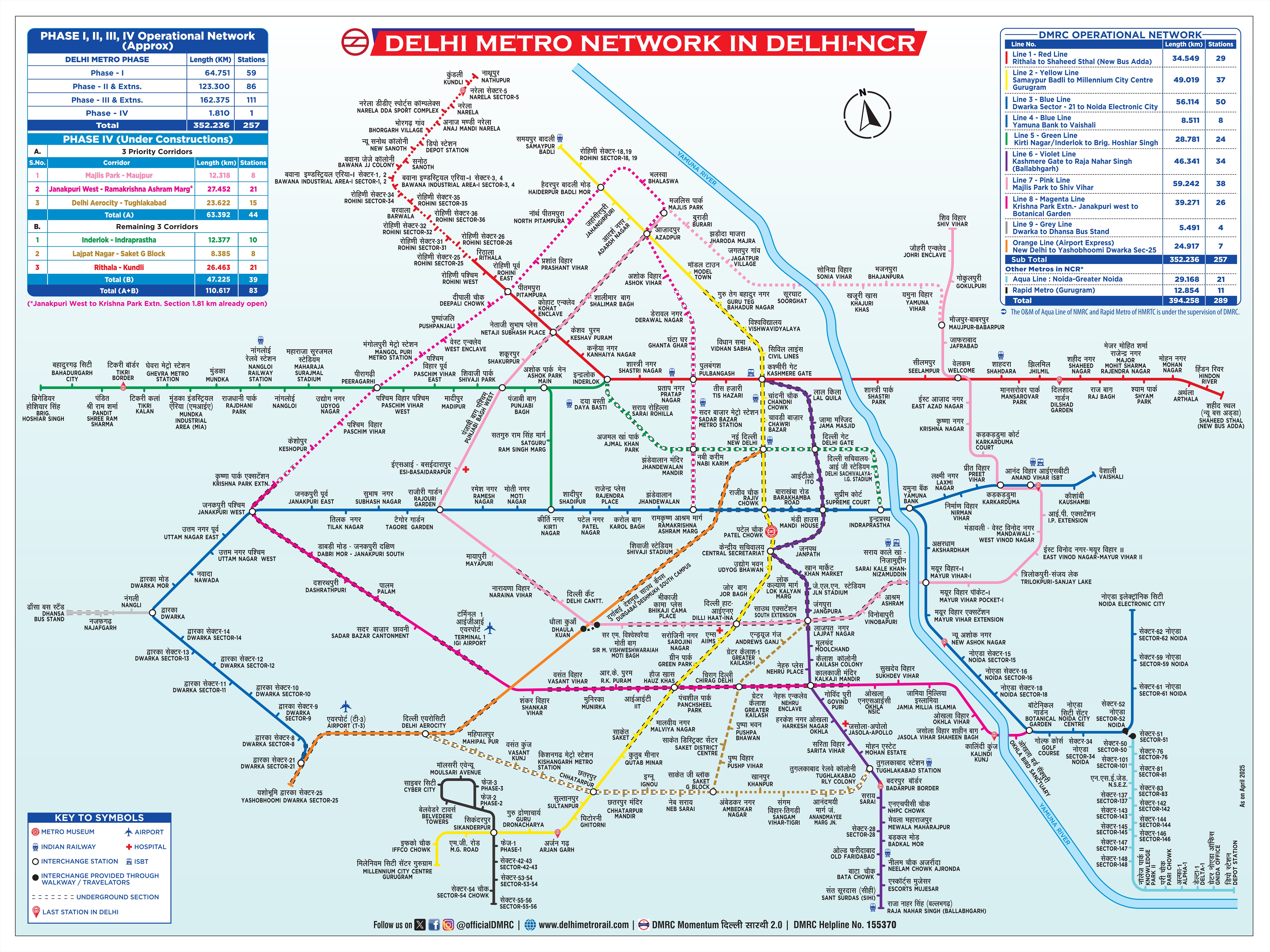
Click to view full size
Frequently Asked Questions
The travel time from Nangloi Railway Station to MG Road is approximately 95 minutes.
This route requires 2 interchanges at Punjabi Bagh West, Dilli Haat INA.
The distance between Nangloi Railway Station and MG Road is approximately 44.0 kilometers.
Yes, this route requires 2 interchanges at Punjabi Bagh West, Dilli Haat INA.
MetroYatra automatically highlights the interchange points and platform directions to make your journey easier.
The metro fare from Nangloi Railway Station to MG Road is ₹64.
Exact fare may vary based on the type of token or card used and the time of day (peak or off-peak).
The route from Nangloi Railway Station to MG Road uses the following metro lines: Green Line, Pink Line, Yellow Line.
MetroYatra shows a detailed map and train direction at each interchange.
The route from Nangloi Railway Station to MG Road takes around 95 minutes via Green Line•Pink Line•Yellow Line.
Route Details:
• Duration: ~95 Minutes
• Distance: ~44.0 Kilometers
• Interchange: 2 Interchanges at Punjabi Bagh West, Dilli Haat INA
• Fare: ₹64
• Metro Lines: Green Line•Pink Line•Yellow Line
Note: Routes are sorted by shortest path first, then by fewest interchanges. Travel times are estimates and may vary based on actual metro schedules.
Found incorrect information? Help us improve!