Ovaripada to Western Express Highway Metro Route Map, Fare, Time & Interchange Details
1 Mumbai Metro Route Available Between Ovaripada & Western Express Highway
This metro route map shows how to travel from Ovaripada Metro Station to Western Express Highway Metro Station using the Mumbai Metro. It includes the complete route map, platform details, total distance, travel time, interchange stations, fare information, and entry and exit gates. You can also check first and last metro timings to plan a smooth and convenient journey.
Below are the available Mumbai Metro routes from Ovaripada to Western Express Highway, including the fastest route and alternative route options.
Fastest Route (41 Minutes) Via Red Line 7•Blue Line 1
Interchange at Gundavali
14 Stations
1 Interchange
₹30
14 Stations
1 Interchange
₹30
Ovaripada
Rashtriya Udyan
Devipada
Magathane
Poisar
Akurli
Kurar
Dindoshi
Aarey
Goregaon (East)
Jogeshwari (East)
Mogra
Gundavali
Western Express Highway
Ovaripada to Western Express Highway Metro Route, Fare, Time, Distance & Interchange Details
Traveling from Ovaripada to Western Express Highway is a journey of approximately 14.6 km. Whether you are a daily commuter or a first-time traveler, this guide provides the fastest route, interchange details, and the latest fare information for 2026.
Route Summary & Journey Stats
| Journey Details | Information |
|---|---|
| Travel Time | ~41 Minutes |
| Ticket Fare | ₹30 (Standard) |
| Total Stations | 14 |
| Interchanges | 1 (Gundavali) |
| Lines Used | Red Line 7, Western Express Highway–Gundavali Foot Overbridge (Pedestrian) |
| Trip Distance | 14.6 km |
This route requires one interchange at Western Express Highway Metro Station, where passengers switch from the Red Line 7 to the Blue Line 1 in the correct direction to reach their destination to reach Western Express Highway.
Fare Data Last Verified: March 2026 · Source: Official fare chart — Mumbai Metro website
Stations Between Ovaripada and Western Express Highway Metro Route
The fastest Mumbai Metro route from Ovaripada Metro Station to Western Express Highway Metro Station passes through 14 stations, including Rashtriya Udyan, Devipada, Magathane, Poisar, and Akurli. Below is the complete station-by-station list.
- Ovaripada Metro Station
- Rashtriya Udyan Metro Station
- Devipada Metro Station
- Magathane Metro Station
- Poisar Metro Station
- Akurli Metro Station
- Kurar Metro Station
- Dindoshi Metro Station
- Aarey Metro Station
- Goregaon (East) Metro Station
- Jogeshwari (East) Metro Station
- Mogra Metro Station
- Gundavali Metro Station
- Western Express Highway Metro Station
Ovaripada to Western Express Highway Metro Route Summary & Navigation
To travel from Ovaripada Metro Station to Western Express Highway Metro Station, passengers need one interchange at Western Express Highway on the Red Line 7 to Blue Line 1 route.
Follow these step-by-step directions:
- 1.Board the Red Line 7 from Ovaripada towards Gundavali.
- 2.Travel 12 stations to Gundavali Metro Station.
This is the fastest Mumbai Metro route from Ovaripada to Western Express Highway, requiring only one interchange at Western Express Highway Metro Station.
The total journey includes 14 metro stations, covers approximately 14.6 km, and takes around 41 minutes via the Red Line 7, Western Express Highway–Gundavali Foot Overbridge (Pedestrian) interchange at Gundavali.
Ovaripada Metro Station Entry & Exit Gates Guide
Ovaripada Metro Station features multiple entry and exit gates connecting passengers to nearby metro lines, commercial areas, and city roads, nearby markets, offices, and surrounding city roads. Choosing the correct gate can help reduce walking distance and make interchanges faster and more convenient.
One Gate: OvariPada, Nancy Colony, Ashok Van, Dahisar Station (Western Line)
Western Express Highway Metro Station Entry & Exit Gates Guide
Western Express Highway Metro Station features multiple entry and exit gates connecting passengers to nearby metro lines, commercial areas, and city roads, nearby markets, offices, and surrounding city roads. Choosing the correct gate can help reduce walking distance and make interchanges faster and more convenient.
Gate 1: Near Landmark Building, Suren Road
Gate 2: Near Gurunanak Petrol Pump
Gate 3: Near BABA House, The Summit Business Bay
Gate 4: Near Mehta Industrial Estate, Holy Family Church
Gate 6: Near Hotel Laxmi Punjab
Gate 7: Near Metro Avenue Building
Gate 8: Toward Highway Exit, Maharaja Restaurant
Return Journey
Planning to travel back? To return to Ovaripada, follow the reverse direction on the metro. Interchange stations and approximate travel time are the same in reverse; check first and last train timings before you board.
Mumbai Metro Network Overview
Find essential details about the Mumbai Metro Network, including operational information, train timings, network scale, and key contact details. This overview helps you quickly understand the system before planning your journey.
Launched Year
2014
Total Lines
4+
Total Stations
68+
Train Length
4 / 6 / 8 Coaches
First Train
5:30 AM
Last Train
11:30 PM
Operator
Mumbai Metro Rail Corporation Limited
Owner
Mumbai Metro Rail Corporation Limited (Joint Venture of Government of India and Government of Maharashtra)
Helpline
18008890808
Mumbai Metro Network Map 2026
View the latest Mumbai Metro Network Map (2026) with all operational lines and stations. The map shows line colors, station sequence, and interchange points to help you understand the network layout and plan your journey more efficiently.
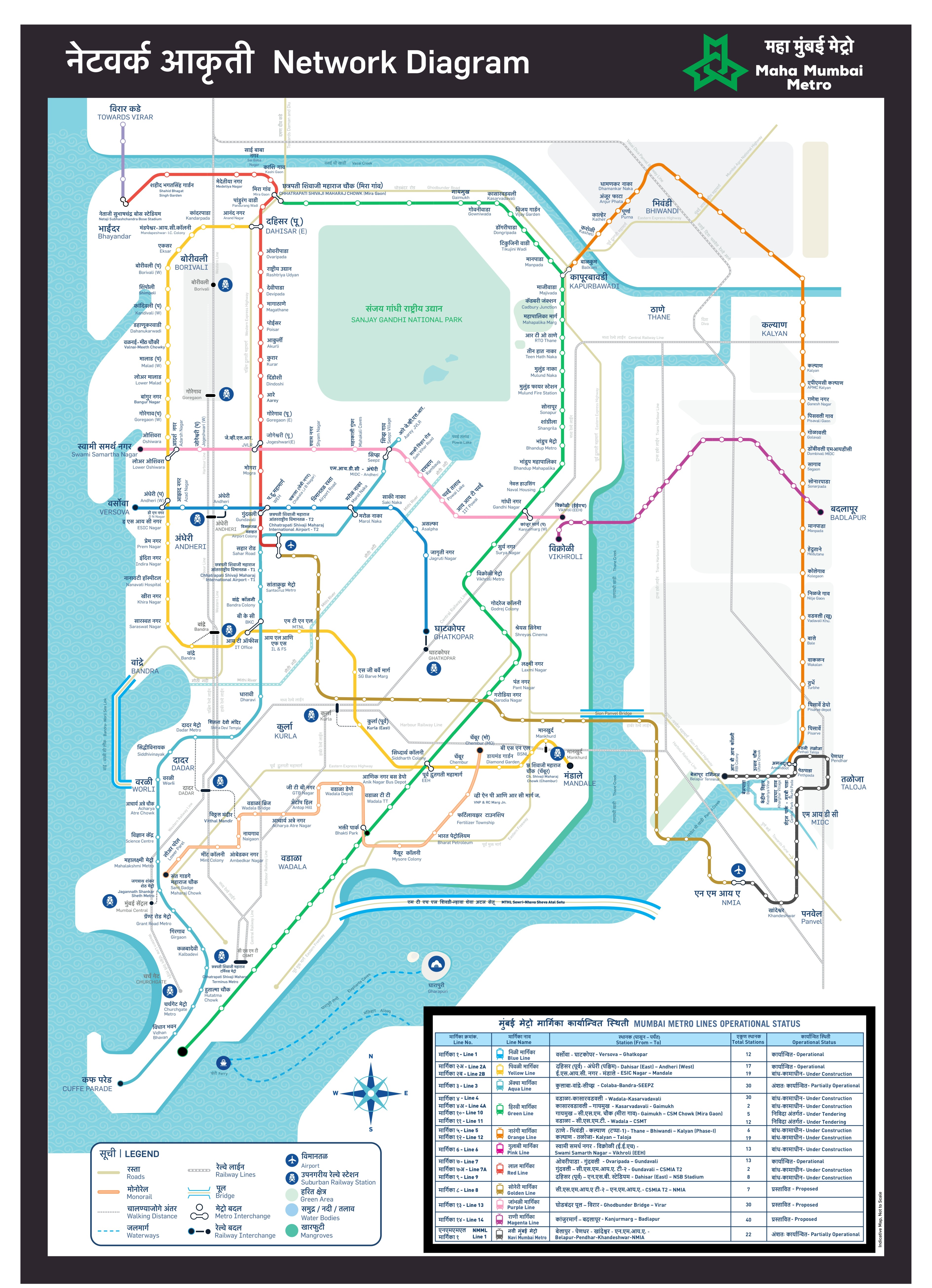
Click to view full size
Frequently Asked Questions
How many metro routes are available from Ovaripada to Western Express Highway?
We found 1 metro route between Ovaripada and Western Express Highway. The fastest option takes 41 minutes via the Red Line 7 and Red Line 7, with one interchange at the interchange station.
How long does it take to travel from Ovaripada to Western Express Highway by metro?
The fastest route takes approximately 41 minutes, covering 14.6 km across Red Line 7 and Red Line 7. This includes an interchange at the interchange station, where you switch platforms — typically a 3–5 minute walk. During peak hours, factor in an extra few minutes as interchange stations see heavier foot traffic.
What is the metro fare from Ovaripada to Western Express Highway?
The standard fare on the fastest route is ₹30. A Mumbai Metro Smart Card (where a 10% discount applies) brings this down to about ₹27 per trip.
Where do I change trains between Ovaripada and Western Express Highway?
You change trains at the interchange station. After boarding the Red Line 7 at Ovaripada (Platform 1, direction Towards Gundavali), travel 1 stops to the interchange station. At the interchange station, follow signs for the Red Line 7 and board towards your destination. The interchange walk typically takes 3–5 minutes — follow the overhead colour-coded signs rather than exiting the station.
What are the first and last metro timings from Ovaripada to Western Express Highway?
Published first and last times are network- and line-level guides; your actual first and last viable journey depends on connections at the interchange station between the Red Line 7 and Red Line 7. Check official Mumbai Metro sources or station displays on the day of travel, especially for early-morning or late-evening trips. For last trains, confirm you can still make the Red Line 7 leg after boarding from Ovaripada.
Is there a direct metro from Ovaripada to Western Express Highway?
No direct route exists between Ovaripada and Western Express Highway — one interchange is required at the interchange station, switching from the Red Line 7 to the Red Line 7. The interchange is well-signposted inside the station and takes 3–5 minutes. This is among the simpler interchange journeys on the Mumbai Metro network.
Note: Routes are sorted by shortest path first, then by fewest interchanges. Travel times are estimates and may vary based on actual metro schedules.
Found incorrect information? Help us improve!