RTC X Roads to KPHB Colony Metro Route Map, Fare, Time & Interchange Details
1 Hyderabad Metro Route Available Between RTC X Roads & KPHB Colony
This metro route map shows how to travel from RTC X Roads Metro Station to KPHB Colony Metro Station using the Hyderabad Metro. It includes the complete route map, platform details, total distance, travel time, interchange stations, fare information, and entry and exit gates. You can also check first and last metro timings to plan a smooth and convenient journey.
Below are the available Hyderabad Metro routes from RTC X Roads to KPHB Colony, including the fastest route and alternative route options.
Fastest Route (52 Minutes) Via Green Line•Red Line
Interchange at MG Bus Station
22 Stations
1 Interchange
₹61
22 Stations
1 Interchange
₹61
RTC X Roads
Chikkadpally
Narayanguda
Sultan Bazaar
MG Bus Station
MG Bus Station
Osmania College
Gandhi Bhavan
Nampally
Assembly
Lakdi Ka Pul
Khairtabad
Irrum Manzil
Punjagutta
Ameerpet
SR Nagar
ESI Hospital
Erragadda
Bharat Nagar
Moosapet
Dr. B.R. Ambedkar Balanagar
Kukatpally
KPHB Colony
RTC X Roads to KPHB Colony Metro Route, Fare, Time, Distance & Interchange Details
Traveling from RTC X Roads to KPHB Colony is a journey of approximately 19.6 km. Whether you are a daily commuter or a first-time traveler, this guide provides the fastest route, interchange details, and the latest fare information for 2026.
Route Summary & Journey Stats
| Journey Details | Information |
|---|---|
| Travel Time | ~52 Minutes |
| Ticket Fare | ₹61 (Standard) |
| Total Stations | 22 |
| Interchanges | 1 (MG Bus Station) |
| Lines Used | Green Line, Red Line |
| Trip Distance | 19.6 km |
This route requires one interchange at MG Bus Station Metro Station, where passengers switch from the Green Line to the Red Line towards Miyapur to reach KPHB Colony.
Fare Data Last Verified: March 2026 · Source: Official fare chart — Hyderabad Metro website
Stations Between RTC X Roads and KPHB Colony Metro Route
The fastest Hyderabad Metro route from RTC X Roads Metro Station to KPHB Colony Metro Station passes through 22 stations, including Chikkadpally, Narayanguda, Sultan Bazaar, MG Bus Station, and MG Bus Station. Below is the complete station-by-station list.
- RTC X Roads Metro Station
- Chikkadpally Metro Station
- Narayanguda Metro Station
- Sultan Bazaar Metro Station
- MG Bus Station Metro Station
- Osmania College Metro Station
- Gandhi Bhavan Metro Station
- Nampally Metro Station
- Assembly Metro Station
- Lakdi Ka Pul Metro Station
- Khairtabad Metro Station
- Irrum Manzil Metro Station
- Punjagutta Metro Station
- Ameerpet Metro Station
- SR Nagar Metro Station
- ESI Hospital Metro Station
- Erragadda Metro Station
- Bharat Nagar Metro Station
- Moosapet Metro Station
- Dr. B.R. Ambedkar Balanagar Metro Station
- Kukatpally Metro Station
- KPHB Colony Metro Station
RTC X Roads to KPHB Colony Metro Route Summary & Navigation
To travel from RTC X Roads Metro Station to KPHB Colony Metro Station, passengers need one interchange at MG Bus Station on the Green Line to Red Line route.
Follow these step-by-step directions:
- 1.Board the Green Line from RTC X Roads towards MG Bus Station.
- 2.Travel 4 stations to MG Bus Station Metro Station.
- 3.At MG Bus Station Metro Station, change from the Green Line to the Red Line towards Miyapur.
- 4.Continue on the Red Line and exit at KPHB Colony Metro Station.
This is the fastest Hyderabad Metro route from RTC X Roads to KPHB Colony, requiring only one interchange at MG Bus Station Metro Station.
The total journey includes 22 metro stations, covers approximately 19.6 km, and takes around 52 minutes via the Green Line, Red Line interchange at MG Bus Station.
RTC X Roads Metro Station Entry & Exit Gates Guide
RTC X Roads Metro Station features multiple entry and exit gates connecting passengers to nearby metro lines, commercial areas, and city roads, nearby markets, offices, and surrounding city roads. Choosing the correct gate can help reduce walking distance and make interchanges faster and more convenient.
Entry and exit gate information is currently not available for this station. We are working to update this information.
KPHB Colony Metro Station Entry & Exit Gates Guide
KPHB Colony Metro Station features multiple entry and exit gates connecting passengers to nearby metro lines, commercial areas, and city roads, nearby markets, offices, and surrounding city roads. Choosing the correct gate can help reduce walking distance and make interchanges faster and more convenient.
Entry and exit gate information is currently not available for this station. We are working to update this information.
Return Journey
Planning to travel back? To return to RTC X Roads, follow the reverse direction on the metro. Interchange stations and approximate travel time are the same in reverse; check first and last train timings before you board.
Hyderabad Metro Network Overview
Find essential details about the Hyderabad Metro Network, including operational information, train timings, network scale, and key contact details. This overview helps you quickly understand the system before planning your journey.
Launched Year
2017
Total Lines
4+
Total Stations
57+
Train Length
3 Coaches
First Train
6:00 AM
Last Train
11:00 PM
Operator
Larsen & Toubro Metro Rail Hyderabad Limited
Owner
Larsen & Toubro Metro Rail Hyderabad Limited (Public–Private Partnership concession granted by Government of Telangana)
Helpline
04023332555
Hyderabad Metro Network Map 2026
View the latest Hyderabad Metro Network Map (2026) with all operational lines and stations. The map shows line colors, station sequence, and interchange points to help you understand the network layout and plan your journey more efficiently.
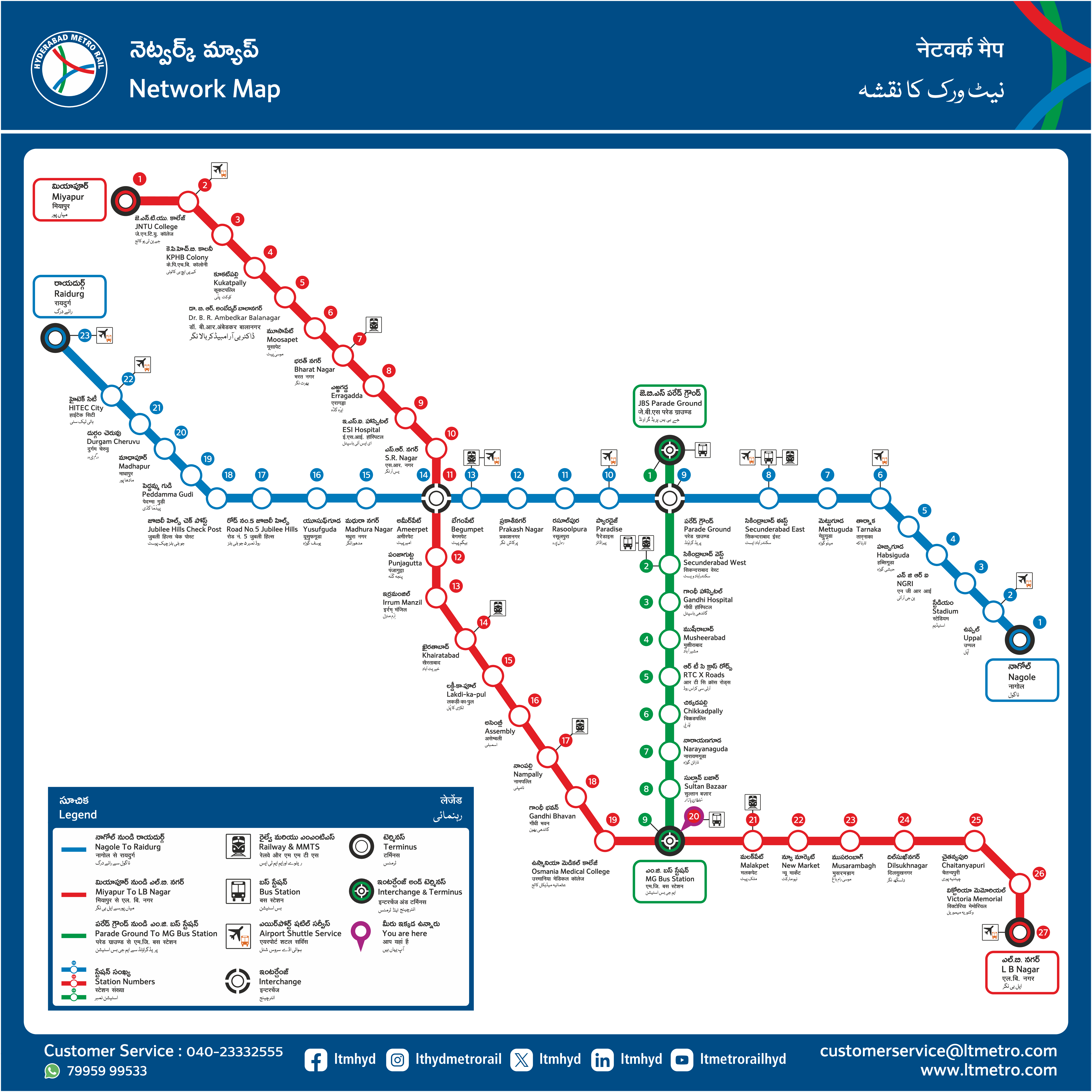
Click to view full size
Frequently Asked Questions
How many metro routes are available from RTC X Roads to KPHB Colony?
We found 1 metro route between RTC X Roads and KPHB Colony. The fastest option takes 52 minutes via the Green Line and Red Line, with one interchange at MG Bus Station.
How long does it take to travel from RTC X Roads to KPHB Colony by metro?
The fastest route takes approximately 52 minutes, covering 19.6 km across Green Line and Red Line. This includes an interchange at MG Bus Station, where you switch platforms — typically a 3–5 minute walk. During peak hours, factor in an extra few minutes as interchange stations see heavier foot traffic.
What is the metro fare from RTC X Roads to KPHB Colony?
The standard fare on the fastest route is ₹61. A Hyderabad Metro Smart Card (where a 10% discount applies) brings this down to about ₹55 per trip.
Where do I change trains between RTC X Roads and KPHB Colony?
You change trains at MG Bus Station. After boarding the Green Line at RTC X Roads (Platform 2, direction Towards MG Bus Station), travel 4 stops to MG Bus Station. At MG Bus Station, follow signs for the Red Line and board towards Towards Miyapur. The interchange walk typically takes 3–5 minutes — follow the overhead colour-coded signs rather than exiting the station.
What are the first and last metro timings from RTC X Roads to KPHB Colony?
Published first and last times are network- and line-level guides; your actual first and last viable journey depends on connections at MG Bus Station between the Green Line and Red Line. Check official Hyderabad Metro sources or station displays on the day of travel, especially for early-morning or late-evening trips. For last trains, confirm you can still make the Red Line leg after boarding from RTC X Roads.
Is there a direct metro from RTC X Roads to KPHB Colony?
No direct route exists between RTC X Roads and KPHB Colony — one interchange is required at MG Bus Station, switching from the Green Line to the Red Line. The interchange is well-signposted inside the station and takes 3–5 minutes. This is among the simpler interchange journeys on the Hyderabad Metro network.
Note: Routes are sorted by shortest path first, then by fewest interchanges. Travel times are estimates and may vary based on actual metro schedules.
Found incorrect information? Help us improve!